coML Mystic Lake
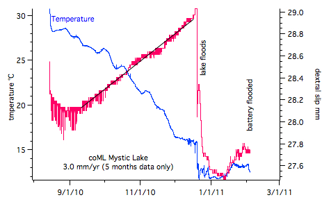
The creepmeter is 12 m long and is buried at a depth of 60 cm at 30 degrees across the Clairmont strand of the San Jacinto fault. THe lake floods after prolonged rain. The location was identified from offset features visible in paleoseismic trenches on each side of the fault (excavated by Tom Rockwell). The installation uses six 3 m deep steel piles driven into the lake clays. See installation report ,. The geological slip rate here is believed to be 10-20 mm/yr.
Data
Data are transmitted currently at 30 minute intervals. Since installation in August until the lake flooded on October 1 mm of dextral slip occurred (3.0 mm/yr). It is possible that the signal is contaminated by a seasonal thermoelastic strain although the initial month of data suggests that this is likely to be small. The damaged data logger will be replaced by a watertight system in the spring of 2011.